
A Map to Get Lost
A Multidisciplinary Installation
Künstlerhaus Bethanien, Berlin
2024
In the weeks after October 7, Jaffa is a place of eerie calm, quiet like a held breath. I stroll through the flea market which just reopened and stumble on a pile of dusty, perfectly preserved maps. Who had kept them pristine for 64 years, and why? What stories do they hold, lying there, waiting. Looking closely; three missing pieces—Jerusalem, Tel Aviv, Gaza. What is this land without these? These 26 maps, drawn in 1960, meticulously detailed the land for the military, never meant for public eyes. Each one whispers, “If found, return me to the police.”
They show a world before 1967, before the Six-Day War redrew the lines tripling Israel’s national territory, removing many, remapping cityscapes, reshaping hierarchies. Who holds the reins? These maps, these silent witnesses to borders that never settle, become the fabric of a new reality I weave. Artefacts of power and control are transformed into something new - a map of a place that’s never been. State borders unravel into threads. In my mind’s eye, Yoko Ono’s 1964 poem, “Map Piece”. “Draw a map to get lost,” she commands. And so I did.


Photos: Boaz Arad, Anton Tal
You are my life's dearest memory
أنت أعز ذكرى في حياتي
דו ביסט די שענסטע ערינערונג פון מיין לעבן
You are my life's dearest memory أنت أعز ذكرى في حياتي דו ביסט די שענסטע ערינערונג פון מיין לעבן
You were the mishap of my life
لقد كنت مصيبة حياتي
דו ביסט געווען דאס אומגליק פון מיין לעבן
You were the mishap of my life لقد كنت مصيبة حياتي דו ביסט געווען דאס אומגליק פון מיין לעבן


Misplaced / Video Piece
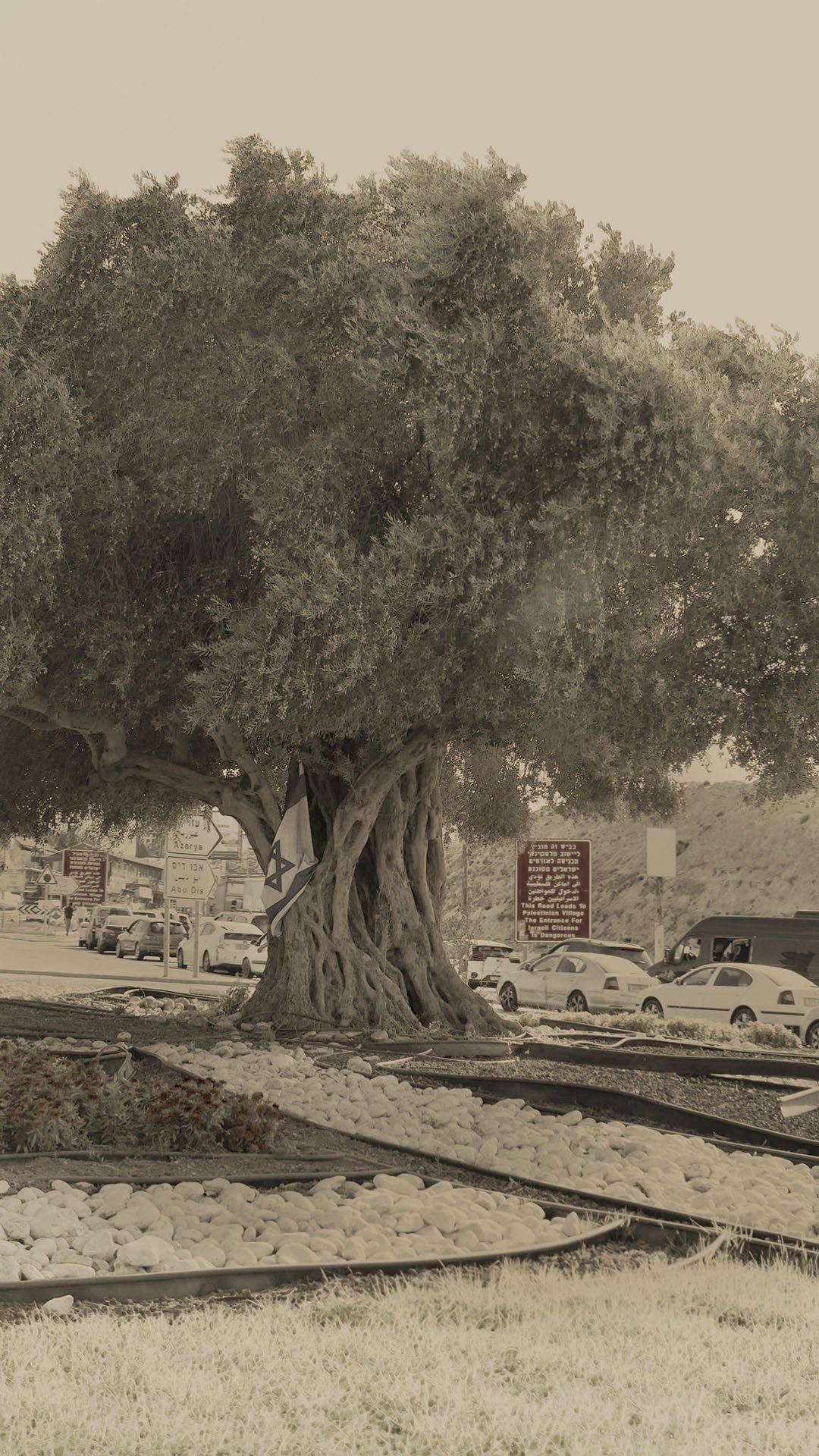
When I was a child, an ancient olive tree was brought to our small town on the outskirts of Jerusalem. It was thick and majestic, a remnant of centuries, but its roots and branches were stumped, severed. Though I couldn’t grasp its depth then, I was flooded with sadness. How did such a noble olive tree end up at the gateway of a wretched town like ours? Where did it come from? Who had tended it through the centuries, and why did they let it be uprooted, only to stand frozen in a roundabout, stranded at the entrance to our suburban town? I watched it hover in midair, suspended between sky and earth, as it was lowered into the ground of the newly paved circle.
Left—Ma'ale Adumim. Right—al-Eizariya.
It has been over twenty years since I last saw that stumped olive tree. Its image, floating between worlds, haunts me. The town has grown, but now, a new reality greets me—a military checkpoint, looming by the tree. We are not allowed to stop the car. Not allowed to film. We circle around it in silence, as I try to capture its image through the window. Round and round, we spiral, orbiting the tree, and the past it holds.
A Map to Get Lost / Sound Piece Composed by Asaf Eden
Developed as an integral part of the installation, in dialogue with the material work and the video piece, the sound piece by Asaf Eden creates a desolate sonic landscape where contemporary and historical contexts constantly flicker.
Get Lost
A short essay by Elad Oren
…In that Empire, the Art of Cartography attained such Perfection that the map of a single Province occupied the entirety of a City, and the map of the Empire, the entirety of a Province. In time, those Unconscionable Maps no longer satisfied, and the Cartographers Guilds struck a Map of the Empire whose size was that of the Empire, and which coincided point for point with it. The following Generations, who were not so fond of the Study of Cartography as their Forebears had been, saw that that vast Map was Useless, and not without some Pitilessness was it, that they delivered it up to the Inclemencies of Sun and Winters. In the Deserts of the West, still today, there are Tattered Ruins of that Map, inhabited by Animals and Beggars; in all the Land there is no other Relic of the Disciplines of Geography.
—Suárez Miranda, Viajes de varones prudentes, Libro IV, Cap. XLV, Lérida, 1658

In his 1946 thought experiment On Exactitude in Science, Jorge Luis Borges demarcates the limits of spatial representation with a map. He describes the attempt to create a perfectly accurate representation of reality with a 1:1 map. By taking the map—an instrument meant to organize and control space—to its logical extreme, Borges reveals the inherent impossibility of any form of representation—whether scientific, artistic, or linguistic—to capture the full complexity of reality. Reality is in constant motion, always changing, and its appearance is shaped by our perspectives, how we choose to see it, and what we project onto it. Thus, the Icarian attempt to create a perfect representation of reality is doomed to fail. Ultimately, the map is abandoned, delivered to the "inclemencies of the sun and winters."
The map structures in this installation were woven from shreds of topographic maps found during a stroll through the tensely quiet flea market in Jaffa, a few weeks after October 7, 2023. The pile contained 26 topographic maps at a scale of 1:100,000, issued in 1960 by the Survey of Israel—the government’s survey and mapping department. The legend of the map, includes the following statement, enclosed in a red frame: ”Disclosing the contents of this document, in whole or in part, to unauthorized individuals constitutes a violation of state security laws. The document's holder is required to deliver it to the nearest Israel Police or Military Police station.” These maps were not intended for public use; they were official tools for various branches of the Israeli government to exert sovereignty over the land. The three-dimensional features of the landscape are depicted by two-dimensional contour lines, with blue and green representing bodies of water and vegetation, and man-made features like infrastructure and settlements marked by lines or black dots. These maps were meant to accurately represent the landscape’s relief and built environment when they were created, twelve years after Israel declared independence.
A light green line hints at why these 26 pristine maps ended up at a flea market, sold for about five euros: they are obsolete. Seven years after their publication, in the Six-Day War, Israel tripled its size by occupying the West Bank, East Jerusalem, the Gaza Strip, the Golan Heights, and the Sinai Desert. In the sixty years since these maps were drawn, the landscape has changed drastically: the land is scarred by an immense network of roads, cities like Tel Aviv have expanded with skyscraper-studded skylines, while nature has retreated—the dying Dead Sea being a prime example.
Moreover, closer examination of the dusty pile revealed that three sections were missing: Tel Aviv, Jerusalem, and the Gaza Strip. Not only were the maps outdated, but they were also incomplete. What kind of representation of Israel and Palestine is it without these three symbolic places? Tel Aviv symbolizes the liberal, open-minded Israel longing to be recognized as part of the Western World. Jerusalem stands as a symbol of the region’s rich, multicultural history and remains a focal point of the Israeli-Palestinian conflict. The Gaza Strip has become a bloody symbol of the ongoing, seemingly endless war.

Much like Borges’ map, these topographic maps were discarded because they were outdated and thus useless, highlighting the temporal nature of the medium: maps are static representations of the environment that can only serve as useful instruments for a limited time, while reality continues to shift. Yet beyond the fact that the maps depict a landscape that has vastly changed, to me, they represent a place that has vanished. When I look at these maps, I see an Israel that no longer exists: a society free from the original sin of the occupation that followed the victory in the Six-Day War. As someone born into the reality shaped by that war, I long for the untainted Israel I never knew. But the Nakba occurred even before Israel occupied territories beyond the Green Line in 1967. This means the “good old Israel” I nostalgically imagine when I look at the maps never truly existed. It is an imaginary paradise: the expulsion of Palestinians was already a reality before the occupation of the West Bank and Gaza Strip.
These maps were misleading; not only would they get you lost, but the place they represent existed only in the imagination. They embody what Borges argued in his story: the attempt to objectively represent reality is inherently futile.
What use are these maps?


In her 1962 MAP PIECE Yoko Ono writes:
Draw an imaginary map.
Put a goal mark on the map where you want to go.
Borges’ conclusion is Ono’s point of departure: her map makes no claim to objective representation; it is imaginary by design. The woven maps in this installation intentionally depict a non-existent space. At first glance, the contours seem familiar, but upon closer inspection, they reveal disorder and a lack of logic, with blurred borders—yet still, somehow, making sense. The old relics were shredded and given new life in the form of an imaginary map, creating an uncanny, fantastical reality that draws us in. The names of some of the Palestinian communities that were erased during the Nakba were written in black ink and absorbed into the paper, a haunting reminder for what the fantasy seeks to conceal.

To reach this promised land, we must walk toward it with our eyes closed. To get there, we must first allow ourselves to get lost in the merging lines of the maps. Only then, freed from the need for control, can we find the place of our longing: a lost Heimat that never existed. An Israel untainted by the corruption of occupation and oppression, a society living in peace with its neighbors and in harmony with nature.
Asaf Eden created a soundtrack that complements the imaginary landscape formed by the woven maps. It consists of a playlist of cut samples, which, like the maps, are woven into each other, reflecting the inherent tension within Israeli culture—the rift between the dream and reality The soundtrack includes songs from military bands following the Six-Day War. These songs, echoing the spirit of the late sixties and the distinctive sound of psychedelic rock, express hope for peace and a longing for the “good old Israel”. By aestheticizing the war and its aftermath through romantic imagery and metaphors drawn from the natural world, these songs create a thin veneer, covering the harsh reality of the occupation that was taking shape during those days.
The songs from these military bands, still played on the radio today—particularly around Memorial Day and Independence Day (for Palestinias, Nakba Day - )—help perpetuate the collective memory that defines the Israeli ethos of longing for peace while fighting wars out of necessity. This ethos is often referred to as “shooting and crying.”
These military bands’ songs are woven into psych-trance tracks, born from the rave scene that emerged in Israel in the 1990s against the backdrop of the optimism sparked by the Oslo Accords and the hope for ending the conflict. Unlike the songs of the military bands, trance music is devoid of national symbols. It is a form of liberation music—liberation of the soul from the body and from oppressive conventions. At the same time, it creates a non-verbal, physical connection, breaking through the limitations of language and culture to establish an unmediated, superlingual bond.

Though the songs of the military bands and psych-trance are essentially different—one aestheticizes war, seeking to create a positive image of the post-Six-Day War reality as a cornerstone of Israeli identity, while the other challenges and subverts this narrative—both reflect a deep yearning among many Israelis for a better life, for a less difficult and violent existence.
The distorted and fragmented songs, interwoven and interrupted by the white noise of radio waves as they hit the folds of the ground in this fantastic space, form the soundtrack of our lives as Israelis—born into this reality, yet choosing to leave it behind. The musical interweaving complements the maps, providing the soundtrack of that imaginary and sublime Land of Israel, where we wish to get lost.


